
Research
The scientific interests of the Geodesy and Tectonophysics Laboratory (GTL) in the Department of Geosciences at Virginia Tech involve elucidating the physical processes that initiate, maintain, and evolve plate tectonics. The interaction of tectonic plates can result in devastating volcanic eruptions and earthquakes, implications of which my research can have immediate and long-term impacts to mitigate hazards. Currently, GTL research addresses these topics by investigating four fundamental questions:
1) How and where is strain accommodated during active tectonics?
2) What balance of forces drive surface deformation from tectonic processes?
3) What are the feedback mechanisms between tectonic deformation, volcanism, and active
seismicity towards a more resilient society?
(4) What are the physical mechanisms driving vertical land motions in regions affected by sea-level
rise?
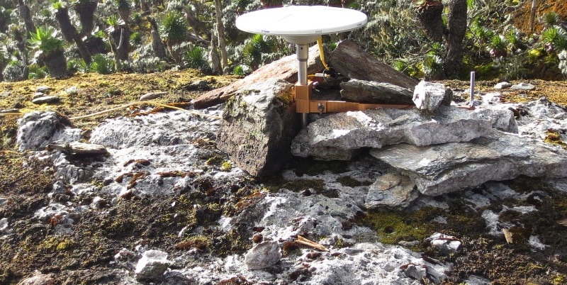
GNSS campaign site in Rwenzori Mountains, Uganda
FUNDING
CURRENT PROJECTS
COLLABORATIONS AND AFFILIATIONS
Example undergraduate projects 1) test fault geometry models for recent earthquakes, 2) test properties of rifts needed to explain previous earthquakes on local structures, 3) implemenet modern tools for cyberinfrastructure development to evaluate lithospheric-modulated convection material paramaters, and 4) development of transient detection algorithms.
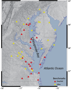
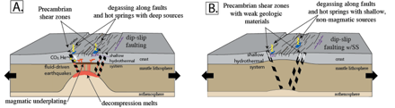
Sea-level rise is a critical process creating hazards on Earth's population. Quantifying vertical land motions in regions experiencing effects from sea-level rise remains an important topic towards resilience to the effects of sea-level rise. We are embarking upon a kinematic and geodynamic study of the Chesapeake Bay of the North American Atlantic Coast in collaboration with the USGS and NOAA to (1) characterize vertical land motion with millimeter precision and (2) conduct numerical modeling to decipher the signals (fingerprints) that comprise the vertical land motions. This project is funded by the USGS (co-PI).
QUANTIFYING AND ASSESSING VERTICAL LAND MOTIONS IN THE CHESAPEAKE BAY
USGS
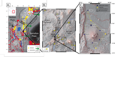
HOW DO VOLCANO-TECTONIC INTERACTIONS INFLUENCE EARLY-PHASE RIFTING?
In this project, we are using the Natron Rift of the East African Rift System as a natural laboratory to study early phase rifting. The active volcano Ol Doinyo Lengai is adjacent to the active border fault, the Natron Fault. We are using GNSS observations, InSAR, and numerial modeling to investigate the role of volcano-tectonic interactions in strain accommodation across the Natron Rift. This work is funded by a NSF CAREER Grant (PI) #1943681. We are expanding to leverage artificial intelligence applications to real-time data for volcanic hazards alerts. Jupyter notebooks: Mason et al. (2021), Dye et al. (2021)
HOW DO MAGMA-POOR CONTINENTAL RIFTS EVOLVE?
In this project we are exploring the physical processes driving magma-poor continental rifting along part of the East African Rift System. Specifically, we are tackling the northern Western Branch in Uganda using a wide-range of techniques such as geochemistry, seismology, structural geology, geodynamics, and geodesy. This project is funded through the NSF Frontiers in Earth Science program (PI) #2021633.
FORMER PROJECTS
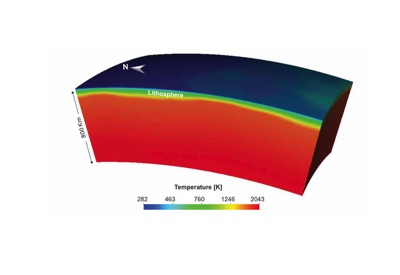
We investigated asthenosphere-lithosphere interactions and upper mantle rheological properties in continental rift settings. In order to study the asthenosphere- lithosphere interactions, we used the NSF CIG community code ASPECT. We created 3D models of a regional mantle flow with distinct independent initial temperature conditions. This was the first 3D regional the lithospheric modulated convection model developed with ASPECT, which is driven temperature perturbations that arise from variations of lithospheric thickness. We also produced a convection model developed with ASPECT based on the conversion of a shear wave velocity model into temperature, which generated buoyancy due to temperature anomalies. In order to validate the mantle flow fields, we compare them with independent observations such as GPS velocity and seismic anisotropy. This work was funded by the NSF GeoPRISMS program (PI) #1551864. Publications: Rajaonarison et al. (2020), Rajaonarison et al. (2021).
WHAT IS THE ROLE OF UPPER MANTLE FLOW ON LITHOSPHERIC DEFORMATION, PARTICULARLY DURING RIFTING IN EAST AFRICA?
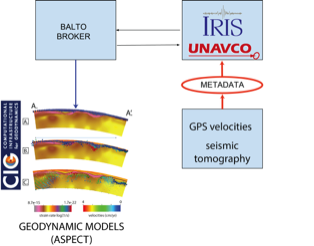
LITHOSPHERE-ASTHENOSPHERE INTERACTIONS, MELT GENERATOIN, AND LITHOSPHERIC DYNAMICS USING MODERN CYBERINFRASTRUCTURE
We tested lithosphere-asthenosphere interactions, melt generation, and lithospheric dynamics with new EarthCube cyberinfrastructure called BALTO (Brokered Alignment of Long-Tail Observations with applications to the Rungwe Volcanic Province in East Africa. We accessed a suite seismic tomography and other models from IRIS to use as initial conditions in geodynamic models run with ASPECT. Model output was compared with independent observations to improve our understanding of lithospheric processes. This project was funded through the NSF EarthCube program #1740704. Publications: Njinju et al. (2019), Nijinju et al. (2021). Jupyter Notebooks: Peckham et al. (2020) Project website: https://sites.google.com/vt.edu/balto/home