Earthquakes Recorded in Virginia: A Primer
In the theory of plate tectonics, the earth's outermost layer is composed of plates that move relative to each other. Most of the world's earthquakes occur at the plate boundaries. Since places like the California coast are on a boundary between two plates, they have many more earthquakes than places like Virginia, which is near the center of the North American plate (Figure 1a). Yet earthquakes still occur in Virginia (Figure 1b).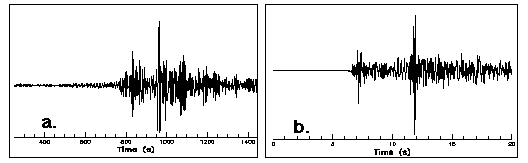
Figure 1: (a) Seismogram of the January 17, 1994 Northridge
earthquake, magnitude 6.8.
(b) Seismogram of the January 22, 1995 Pulaski earthquake,
magnitude 2.9. Both events were recorded on a seismograph in
Blacksburg, Virginia.
Virginia has had over 160 earthquakes since 1977 of which 16% were felt. This equates to an average of one earthquake occurring every month with two felt each year. Click here for a summary of the largest earthquakes in Virginia.
The largest earthquake to occur in Virginia is the 1897 magnitude 5.8 Giles County earthquake. This earthquake is the third largest in the eastern US in the last 200 years and was felt in twelve states. Click here for a discussion on the observed effects of this event.
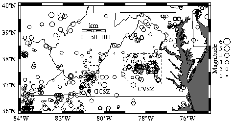
Seismic activity (seismicity) has been known for several decades to be strongest in and around Giles County and in central Virginia. This led researchers at the VTSO to concentrate seismic monitoring stations in these two areas, as shown in Figure 2, which shows earthquakes (circles, scaled to magnitude) in and near Virginia from 1774 through 1994.